
Make a donation
Gear up for your next adventure:
As an Amazon Associate, this site earns from qualifying purchases at no extra cost to you.
Kremna topographic map
Click on the map to display elevation.
Make a donation
Gear up for your next adventure:
As an Amazon Associate, this site earns from qualifying purchases at no extra cost to you.
About this map
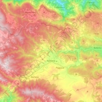
Name: Kremna topographic map, elevation, terrain.
Average elevation: 880 m
Minimum elevation: 393 m
Maximum elevation: 1,249 m
Make a donation
Gear up for your next adventure:
As an Amazon Associate, this site earns from qualifying purchases at no extra cost to you.
Other topographic maps
Click on a map to view its topography, its elevation and its terrain.
Tara
Serbia > Central Serbia > Zlatibor Administrative District > Uzice
Tara (Serbian Cyrillic: Тара, pronounced [târa]) is a mountain in western Serbia. It is part of the Dinaric Alps and stands at 1,000 to 1,590 m (3,280 to 5,220 ft) above sea level. The mountain's slopes are clad in dense forests with numerous high-elevation clearings and meadows, steep cliffs, deep…
Average elevation: 1,325 m
Make a donation
Gear up for your next adventure:
As an Amazon Associate, this site earns from qualifying purchases at no extra cost to you.