Geolocate

Waimea topographic map

Click on the map to display elevation.

About this map

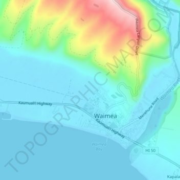
Name: Waimea topographic map, elevation, terrain.

Location: Waimea, Kauaʻi County, Hawaii, United States (21.95112 -159.69346 21.97617 -159.65528)

Average elevation: 59 m

Minimum elevation: 0 m

Maximum elevation: 301 m

Gear up for your next adventure:

🧶550 Survival Paracord - Versatile utility cord for emergency repairs and rigging
🥾Trail Hiking Boots - Supportive boots for rough trails
🧢Sun Protection Cap - Breathable cap to protect from sun exposure
❄️Traction Ice Cleats - Slip-on spikes for icy trails and winter hiking
Camping Tent - Weather-resistant tents suitable for 2 to 6 people

As an Amazon Associate, this site earns from qualifying purchases at no extra cost to you.