Geolocate

Bihta topographic map

Click on the map to display elevation.

About this map

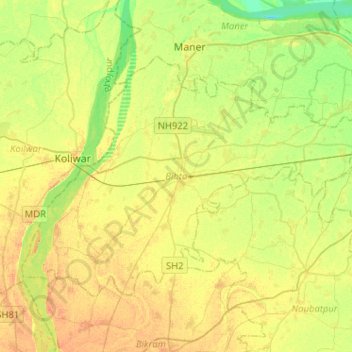
Name: Bihta topographic map, elevation, terrain.

Location: Bihta, Patna, Bihar, India (25.48264 84.75422 25.64091 85.00970)

Average elevation: 57 m

Minimum elevation: 40 m

Maximum elevation: 71 m

Gear up for your next adventure:

🧥Packable Rain Jacket - Breathable waterproof layer for unpredictable weather
🛏️Camping Sleeping Mat - Comfortable mats for sleeping outdoors
🧥Softshell Jacket - Windproof and breathable jacket for hiking
🕶️Polarized Sunglasses - Protect your eyes with durable polarized lenses
🦟Insect Repellent - Keep mosquitoes and black flies away in wooded areas

As an Amazon Associate, this site earns from qualifying purchases at no extra cost to you.