Geolocate

zonas verdes topographic map

Click on the map to display elevation.

About this map

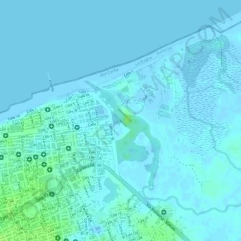
Name: zonas verdes topographic map, elevation, terrain.

Location: zonas verdes, Riohacha, La Guajira, 44001, Colombia (11.55076 -72.90077 11.55086 -72.90067)

Average elevation: 2 m

Minimum elevation: -2 m

Maximum elevation: 13 m

Other topographic maps

Click on a map to view its topography, its elevation and its terrain.

Laguna Salada

Colombia > La Guajira > Riohacha

Average elevation: 6 m

Río Ranchería

Colombia > La Guajira > Riohacha

Average elevation: 3 m

Gear up for your next adventure:

🥫Freeze-Dried Meals - Lightweight, high-calorie nutrition for multi-day treks
🔋Lithium AA Batteries - Long-lasting power that performs in extreme cold
Backpacking Tent - Lightweight tent for long-distance hiking trips
🧥Softshell Hiking Jacket - The perfect balance of wind protection and breathability
🥾Mountain Trail Shoes - High-traction shoes for mountain trails

As an Amazon Associate, this site earns from qualifying purchases at no extra cost to you.