
Thank you for supporting this site ❤️
Make a donation
Make a donation
Gear up for your next adventure:
As an Amazon Associate, this site earns from qualifying purchases at no extra cost to you.
Panzendorf topographic map
Click on the map to display elevation.
Thank you for supporting this site ❤️
Make a donation
Make a donation
Gear up for your next adventure:
As an Amazon Associate, this site earns from qualifying purchases at no extra cost to you.
About this map
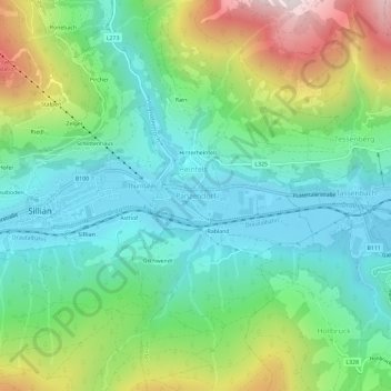
Name: Panzendorf topographic map, elevation, terrain.
Location: Panzendorf, Heinfels, Bezirk Lienz, Tirolo, 9919, Austria (46.72883 12.42131 46.76883 12.46131)
Average elevation: 1,345 m
Minimum elevation: 1,063 m
Maximum elevation: 1,990 m
Thank you for supporting this site ❤️
Make a donation
Make a donation
Gear up for your next adventure:
As an Amazon Associate, this site earns from qualifying purchases at no extra cost to you.
Other topographic maps
Click on a map to view its topography, its elevation and its terrain.