Geolocate

Herford topographic map

Click on the map to display elevation.

About this map

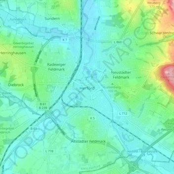
Name: Herford topographic map, elevation, terrain.

Location: Herford, Kreis Herford, North Rhine-Westphalia, Germany (52.08628 8.63632 52.14486 8.72671)

Average elevation: 91 m

Minimum elevation: 59 m

Maximum elevation: 217 m

Gear up for your next adventure:

🕶️Polarized Sunglasses - Reduces glare from snow and water at high elevations
🧴Outdoor Sunscreen - High SPF protection for high-altitude UV exposure
🩹Compact First Aid Kit - Pre-packed essentials for common trail injuries
🧦Crew Hiking Socks - Comfortable socks for long-distance hikes
🛶Kayak Dry Bag - Waterproof storage for kayaking adventures

As an Amazon Associate, this site earns from qualifying purchases at no extra cost to you.