
Thank you for supporting this site ❤️
Make a donation
Make a donation
Gear up for your next adventure:
As an Amazon Associate, this site earns from qualifying purchases at no extra cost to you.
O Outeiro topographic map
Click on the map to display elevation.
Thank you for supporting this site ❤️
Make a donation
Make a donation
Gear up for your next adventure:
As an Amazon Associate, this site earns from qualifying purchases at no extra cost to you.
About this map
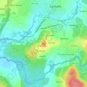
Name: O Outeiro topographic map, elevation, terrain.
Location: O Outeiro, Carballo, La Coruña, Galicia, 15102, España (43.20178 -8.69430 43.20188 -8.69420)
Average elevation: 118 m
Minimum elevation: 94 m
Maximum elevation: 179 m
Thank you for supporting this site ❤️
Make a donation
Make a donation
Gear up for your next adventure:
As an Amazon Associate, this site earns from qualifying purchases at no extra cost to you.