
Make a donation
Gear up for your next adventure:
As an Amazon Associate, this site earns from qualifying purchases at no extra cost to you.
Brooksville topographic map
Click on the map to display elevation.
Make a donation
Gear up for your next adventure:
As an Amazon Associate, this site earns from qualifying purchases at no extra cost to you.
Brooksville
Brooksville is known for its rolling topography with elevations ranging from 100 ft to 180 ft. The highest elevation in the area is Chinsegut Hill, at 269 ft, over five and a half miles north of the city.
Make a donation
Gear up for your next adventure:
As an Amazon Associate, this site earns from qualifying purchases at no extra cost to you.
About this map
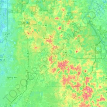
Name: Brooksville topographic map, elevation, terrain.
Location: Brooksville, Hernando County, Florida, United States (28.48943 -82.42877 28.58760 -82.33845)
Average elevation: 38 m
Minimum elevation: 12 m
Maximum elevation: 86 m
Make a donation
Gear up for your next adventure:
As an Amazon Associate, this site earns from qualifying purchases at no extra cost to you.
Other topographic maps
Click on a map to view its topography, its elevation and its terrain.
Spring Lake
United States > Florida > Hernando County
Spring Lake contains rolling hills ranging in elevation from 120ft to 280ft.
Average elevation: 49 m
Make a donation
Gear up for your next adventure:
As an Amazon Associate, this site earns from qualifying purchases at no extra cost to you.
Ridge Manor
United States > Florida > Hernando County > Brooksville > Ridge Manor
Average elevation: 22 m
Make a donation
Gear up for your next adventure:
As an Amazon Associate, this site earns from qualifying purchases at no extra cost to you.
Make a donation
Gear up for your next adventure:
As an Amazon Associate, this site earns from qualifying purchases at no extra cost to you.
Ridge Manor
United States > Florida > Hernando County > Brooksville > Ridge Manor
Average elevation: 22 m
Make a donation
Gear up for your next adventure:
As an Amazon Associate, this site earns from qualifying purchases at no extra cost to you.
Spring Lake
United States > Florida > Hernando County > Spring Lake
Spring Lake contains rolling hills ranging in elevation from 120ft to 280ft.
Average elevation: 49 m
Make a donation
Gear up for your next adventure:
As an Amazon Associate, this site earns from qualifying purchases at no extra cost to you.
Spring Lake
United States > Florida > Hernando County
Spring Lake contains rolling hills ranging in elevation from 120ft to 280ft.
Average elevation: 49 m
Make a donation
Gear up for your next adventure:
As an Amazon Associate, this site earns from qualifying purchases at no extra cost to you.
Make a donation
Gear up for your next adventure:
As an Amazon Associate, this site earns from qualifying purchases at no extra cost to you.