Geolocate

Quiberville-sur-Mer topographic map

Click on the map to display elevation.

About this map
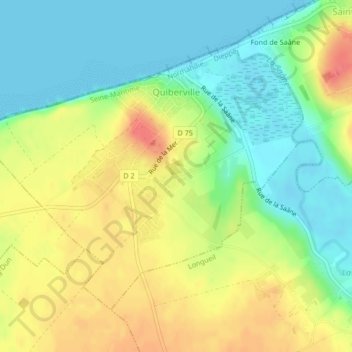
Name: Quiberville-sur-Mer topographic map, elevation, terrain.

Location: Quiberville-sur-Mer, Dieppe, Seine-Maritime, Normandy, Metropolitan France, 76860, France (49.88638 0.89902 49.90691 0.93840)

Average elevation: 27 m

Minimum elevation: 0 m

Maximum elevation: 61 m

Other topographic maps

Click on a map to view its topography, its elevation and its terrain.
Saint-Adrien

France > Normandy > Seine-Maritime > Belbeuf

Average elevation: 56 m

Puys Beach

France > Normandy > Seine-Maritime > Dieppe > Puys

Average elevation: 30 m

Le Pollet

France > Normandy > Seine-Maritime > Torcy-le-Petit

Average elevation: 84 m

Edreville

France > Normandy > Seine-Maritime > Octeville-sur-Mer

Average elevation: 78 m

La Grand Route

France > Normandy > Seine-Maritime > Écalles-Alix

Average elevation: 147 m

La Fresnaye

France > Normandy > Seine-Maritime > Buchy

Average elevation: 201 m

Le Pière

France > Normandy > Seine-Maritime > Étaimpuis

Average elevation: 157 m

Gear up for your next adventure:

🧢Outdoor Cap - Protective cap for sun and rain during hikes
🧥Waterproof Hiking Jacket - Protect yourself from rain and wind while hiking
🧥Ultralight Puffy Jacket - Maximum warmth that packs down to the size of an orange
🍽️Titanium Camping Spork - Ultralight and indestructible eating utensil
🧥Softshell Hiking Jacket - The perfect balance of wind protection and breathability

As an Amazon Associate, this site earns from qualifying purchases at no extra cost to you.