
Make a donation
Gear up for your next adventure:
As an Amazon Associate, this site earns from qualifying purchases at no extra cost to you.
Rabodanges topographic map
Click on the map to display elevation.
Make a donation
Gear up for your next adventure:
As an Amazon Associate, this site earns from qualifying purchases at no extra cost to you.
About this map
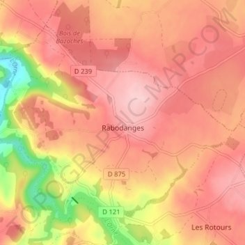
Name: Rabodanges topographic map, elevation, terrain.
Average elevation: 188 m
Minimum elevation: 72 m
Maximum elevation: 243 m
Make a donation
Gear up for your next adventure:
As an Amazon Associate, this site earns from qualifying purchases at no extra cost to you.
Other topographic maps
Click on a map to view its topography, its elevation and its terrain.
Lac de Rabodanges
France > Normandie > Orne > Putanges-le-Lac > Sainte-Croix-sur-Orne
Average elevation: 176 m
Le Châtelier
France > Normandie > Orne > Putanges-le-Lac > Putanges-Pont-Écrepin
Average elevation: 186 m
Le Buisson
France > Normandie > Orne > Putanges-le-Lac > Putanges-Pont-Écrepin
Average elevation: 191 m
Make a donation
Gear up for your next adventure:
As an Amazon Associate, this site earns from qualifying purchases at no extra cost to you.
Les Courtils
France > Normandie > Orne > Putanges-le-Lac > Putanges-Pont-Écrepin
Average elevation: 186 m
Le Hamel
France > Normandie > Orne > Putanges-le-Lac > La Forêt-Auvray > Le Hamel
Average elevation: 173 m
Lac de Rabodanges
France > Normandie > Orne > Putanges-le-Lac > Sainte-Croix-sur-Orne
Average elevation: 176 m
Make a donation
Gear up for your next adventure:
As an Amazon Associate, this site earns from qualifying purchases at no extra cost to you.