Geolocate

Tumu topographic map

Click on the map to display elevation.

About this map

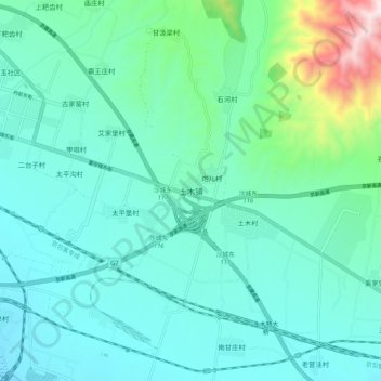
Name: Tumu topographic map, elevation, terrain.

Location: Tumu, Zhangjiakou, Hebei, China (40.34758 115.55170 40.42758 115.63170)

Average elevation: 627 m

Minimum elevation: 477 m

Maximum elevation: 1,334 m

Other topographic maps

Click on a map to view its topography, its elevation and its terrain.

Dongwangshan

China > Hebei > Zhangjiakou

Average elevation: 1,038 m

Qiaoxi District

China > Hebei > Zhangjiakou

Average elevation: 917 m

Zhuolu County

China > Hebei > Zhangjiakou

Average elevation: 1,036 m

Huai'an County

China > Hebei > Zhangjiakou

Average elevation: 1,103 m

Yangyuan County

China > Hebei > Zhangjiakou

Average elevation: 1,163 m

Gear up for your next adventure:

🧥Insulated Jacket - Keep warm in cold outdoor conditions
🛏️Camping Sleeping Mat - Comfortable mats for sleeping outdoors
🥘Camping Cookware Set - Compact nesting pots and pans for trail cooking
Tent Footprint - Protect tent floor and increase durability
Lightweight Camping Tent - Portable shelter optimized for Canadian backcountry camping

As an Amazon Associate, this site earns from qualifying purchases at no extra cost to you.