Wrocław topographic map
Click on the map to display elevation.
Wrocław
Wrocław is located in the three mesoregions of the Silesian Lowlands (Wrocław Plain, Wrocław Valley, Oleśnica Plain) at an elevation of around 156–170 meters (Gajowe Hill and Maślickie Hill) above sea level. The city lies on the Oder River and its four tributaries, which supply it within the city limits – Bystrzyca, Oława, Ślęza and Widawa. In addition, the Dobra River and many streams flow through the city. The city has a sewage treatment plant on the Janówek estate.
About this map
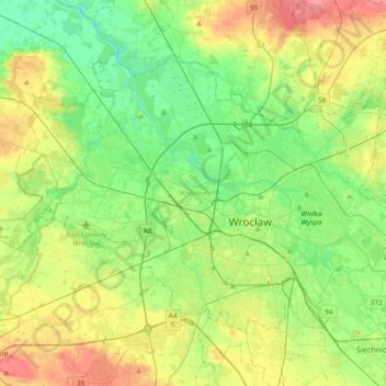
Name: Wrocław topographic map, elevation, terrain.
Location: Wrocław, Trzebnica County, Lower Silesian Voivodeship, Poland (51.04267 16.80734 51.21006 17.17622)
Average elevation: 125 m
Minimum elevation: 99 m
Maximum elevation: 170 m
Other topographic maps
Click on a map to view its topography, its elevation and its terrain.
Sudety
Poland > Lower Silesian Voivodeship > Ząbkowice Śląskie County > Starczówek
Average elevation: 293 m