Geolocate

Sangi topographic map

Click on the map to display elevation.

About this map

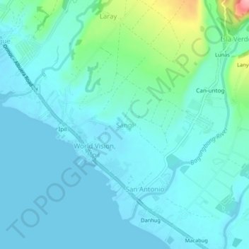
Name: Sangi topographic map, elevation, terrain.

Location: Sangi, Ormoc, Leyte, Eastern Visayas, 6541, Philippines (10.95605 124.62335 10.99605 124.66335)

Average elevation: 22 m

Minimum elevation: 0 m

Maximum elevation: 141 m

Other topographic maps

Click on a map to view its topography, its elevation and its terrain.

Binahaan River

Philippines > Leyte > Ormoc

Average elevation: 546 m

Binahaan River

Philippines > Leyte > Ormoc

Average elevation: 495 m

Ormoc City Proper

Philippines > Leyte > Ormoc

Average elevation: 18 m

Gear up for your next adventure:

🥫Freeze-Dried Meals - Lightweight, high-calorie nutrition for multi-day treks
🥾Mountaineering Boots - Supportive boots for climbing and high-altitude hiking
🔦LED Headtorch - Bright and durable light for night activities
🥾Waterproof Hiking Shoes - Durable shoes for wet and rugged trails
🧭GPS Outdoor Watch - Smart watch for navigation and fitness tracking in nature

As an Amazon Associate, this site earns from qualifying purchases at no extra cost to you.