Geolocate

Isa topographic map

Click on the map to display elevation.

About this map

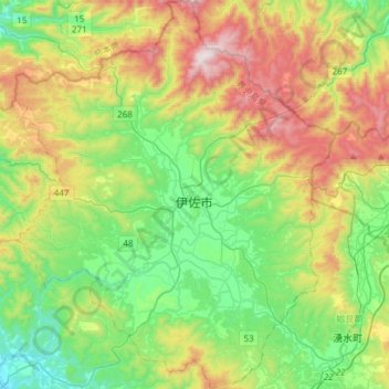
Name: Isa topographic map, elevation, terrain.

Location: Isa, Kagoshima Prefecture, Japan (31.93487 130.47554 32.18750 130.72127)

Average elevation: 363 m

Minimum elevation: 31 m

Maximum elevation: 984 m

Gear up for your next adventure:

🧭GPS Outdoor Watch - Smart watch for navigation and fitness tracking in nature
🧤Thermal Hiking Gloves - Grip-enhanced gloves for cold-weather altitude trekking
🎒Backpack Rain Cover - External shield to keep your entire pack dry
🔦LED Headtorch - Bright and durable light for night activities
🥾Lightweight Hiking Boots - Boots for comfort and mobility on long hikes

As an Amazon Associate, this site earns from qualifying purchases at no extra cost to you.