
Thank you for supporting this site ❤️
Make a donation
Make a donation
Gear up for your next adventure:
As an Amazon Associate, this site earns from qualifying purchases at no extra cost to you.
Kiriburu topographic map
Click on the map to display elevation.
Thank you for supporting this site ❤️
Make a donation
Make a donation
Gear up for your next adventure:
As an Amazon Associate, this site earns from qualifying purchases at no extra cost to you.
About this map
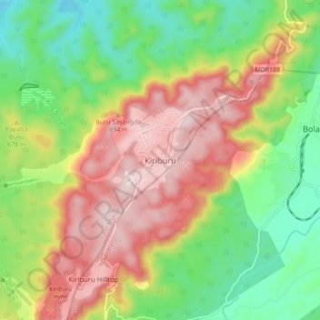
Name: Kiriburu topographic map, elevation, terrain.
Location: Kiriburu, Noamundi, West Singhbhum, Jharkhand, 833222, India (22.06529 85.25467 22.14529 85.33467)
Average elevation: 633 m
Minimum elevation: 389 m
Maximum elevation: 931 m
Thank you for supporting this site ❤️
Make a donation
Make a donation
Gear up for your next adventure:
As an Amazon Associate, this site earns from qualifying purchases at no extra cost to you.