
Corps topographic map
Interactive map
Click on the map to display elevation.
About this map
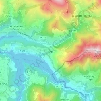
Name: Corps topographic map, elevation, terrain.
Average elevation: 1,084 m
Minimum elevation: 739 m
Maximum elevation: 1,918 m
Other topographic maps
Click on a map to view its topography, its elevation and its terrain.
La Salette
Francia > Auvergne-Rhône-Alpes > Isère > Bellegarde-Poussieu
La Salette, Bellegarde-Poussieu, Vienne, Isère, Auvergne-Rhône-Alpes, Francia metropolitana, 38270, Francia
Average elevation: 368 m