Geolocate

Honolulu topographic map

Click on the map to display elevation.

About this map

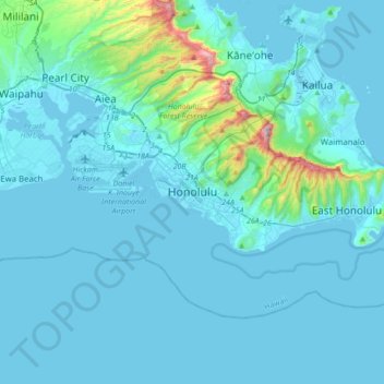
Name: Honolulu topographic map, elevation, terrain.

Location: Honolulu, Honolulu County, Hawaii, 96813, United States (21.14455 -158.01568 21.46455 -157.69568)

Average elevation: 71 m

Minimum elevation: -2 m

Maximum elevation: 928 m

Other topographic maps

Click on a map to view its topography, its elevation and its terrain.

Pupukea

United States > Hawaii > Honolulu County

Average elevation: 51 m

Gear up for your next adventure:

👟Leg Gaiters - Keep debris, mud, and snow out of your boots
🩹Compact First Aid Kit - Pre-packed essentials for common trail injuries
💡Solar Camping Lamp - Eco-friendly lighting for campsites
🧰Multitool Knife - Compact and versatile tool for outdoor use
Bushcraft Tarp - Versatile emergency shelter or gear protection

As an Amazon Associate, this site earns from qualifying purchases at no extra cost to you.