Geolocate

South Madison topographic map

Click on the map to display elevation.

About this map

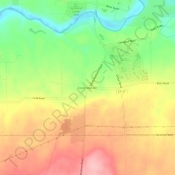
Name: South Madison topographic map, elevation, terrain.

Location: South Madison, Lake County, Ohio, United States (41.70533 -81.07010 41.74533 -81.03010)

Average elevation: 280 m

Minimum elevation: 205 m

Maximum elevation: 350 m

Other topographic maps

Click on a map to view its topography, its elevation and its terrain.

Grand River

United States > Ohio > Lake County

Average elevation: 182 m

Fairport Harbor

United States > Ohio > Lake County

Average elevation: 182 m

Wickliffe

United States > Ohio > Lake County

Average elevation: 226 m

Painesville

United States > Ohio > Lake County

Average elevation: 200 m

Kirtland Hills

United States > Ohio > Lake County

Average elevation: 270 m

Willowick

United States > Ohio > Lake County

Average elevation: 188 m

Gear up for your next adventure:

📷Outdoor Action Camera - Capture high-elevation views and rugged adventures
🥾Mountain Hiking Shoes - Shoes with superior grip for mountainous terrain
🗺️Topographic Maps - Detailed maps to explore trails, mountains, and wilderness areas
🏕️Camping Hammock - Integrated protection for sleeping between trees
🎒Backpack Rain Cover - External shield to keep your entire pack dry

As an Amazon Associate, this site earns from qualifying purchases at no extra cost to you.