
Make a donation
Gear up for your next adventure:
As an Amazon Associate, this site earns from qualifying purchases at no extra cost to you.
Portalegre topographic map
Click on the map to display elevation.
Make a donation
Gear up for your next adventure:
As an Amazon Associate, this site earns from qualifying purchases at no extra cost to you.
Portalegre
The city is located at an altitude of between 400 and 600 m (1,300 and 2,000 ft), in the transition zone between the relatively flat landscape, but with many low hills to the south and west, and the mountainous system of Serra de São Mamede, which surrounds it to the north, east and southeast.
Make a donation
Gear up for your next adventure:
As an Amazon Associate, this site earns from qualifying purchases at no extra cost to you.
About this map
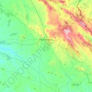
Name: Portalegre topographic map, elevation, terrain.
Location: Portalegre, Portugal (39.14624 -7.55853 39.39874 -7.23147)
Average elevation: 431 m
Minimum elevation: 208 m
Maximum elevation: 1,021 m
Make a donation
Gear up for your next adventure:
As an Amazon Associate, this site earns from qualifying purchases at no extra cost to you.
Other topographic maps
Click on a map to view its topography, its elevation and its terrain.
Relva da Asseiceira
Portugal > Portalegre > Marvão > Santo António das Areias
Average elevation: 482 m
Make a donation
Gear up for your next adventure:
As an Amazon Associate, this site earns from qualifying purchases at no extra cost to you.
Make a donation
Gear up for your next adventure:
As an Amazon Associate, this site earns from qualifying purchases at no extra cost to you.