
Peto topographic map
Interactive map
Click on the map to display elevation.
About this map
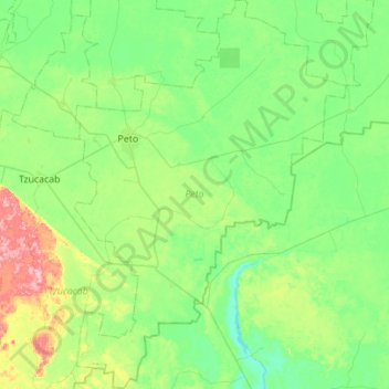
Name: Peto topographic map, elevation, terrain.
Location: Peto, Yucatán, 97930, México (19.79095 -88.99971 20.31087 -88.61266)
Average elevation: 34 m
Minimum elevation: 0 m
Maximum elevation: 149 m
Other topographic maps
Click on a map to view its topography, its elevation and its terrain.
San Ignacio
México > Yucatán > San Ignacio
San Ignacio, Progreso, Yucatán, México
Average elevation: 5 m
San Felipe Nuevo
México > Yucatán > San Felipe Nuevo
San Felipe Nuevo, Tinum, Yucatán, 97751, México
Average elevation: 27 m
José María Morelos y Pavón
México > Yucatán > José María Morelos y Pavón
José María Morelos y Pavón, Teya, Yucatán, México
Average elevation: 9 m