Geolocate

Cottondale topographic map

Click on the map to display elevation.

About this map

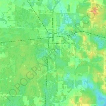
Name: Cottondale topographic map, elevation, terrain.

Location: Cottondale, Jackson County, Florida, United States (30.76290 -85.39030 30.81198 -85.33041)

Average elevation: 45 m

Minimum elevation: 29 m

Maximum elevation: 65 m

Other topographic maps

Click on a map to view its topography, its elevation and its terrain.

Compass Lake

United States > Florida > Jackson County

Average elevation: 66 m

Haynes

United States > Florida > Jackson County > Haynes

Average elevation: 28 m

Cypress

United States > Florida > Jackson County > Cypress

Average elevation: 41 m

Gear up for your next adventure:

🧥Softshell Jacket - Windproof and breathable jacket for hiking
🪑Insulated Seat Pad - Protect your seat from cold rocks and wet logs
🕯️Camping Lantern - Illuminates your entire campsite with high-efficiency LEDs
🔭Compact Binoculars - Lightweight optics for scouting trails and wildlife
🧥Waterproof Pants - Keep dry during rainy hiking conditions

As an Amazon Associate, this site earns from qualifying purchases at no extra cost to you.