Geolocate

Mata Ayer topographic map

Click on the map to display elevation.

About this map

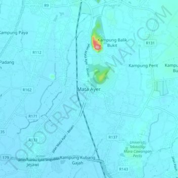
Name: Mata Ayer topographic map, elevation, terrain.

Location: Mata Ayer, Perlis, 02500, Malaysia (6.43686 100.21911 6.51686 100.29911)

Average elevation: 15 m

Minimum elevation: 3 m

Maximum elevation: 272 m

Other topographic maps

Click on a map to view its topography, its elevation and its terrain.

Timah Tasoh Reservoir

Malaysia > Perlis

Average elevation: 32 m

Sungai Batu Pahat

Malaysia > Perlis > Sungai Batu Pahat

Average elevation: 86 m

View Point Wang Kelian

Malaysia > Perlis

Average elevation: 158 m

Sungai Tepoh

Malaysia > Perlis > Kangar

Average elevation: 6 m

Sungai Kayang

Malaysia > Perlis > Kuala Perlis

Average elevation: 19 m

Perlis River

Malaysia > Perlis > Kangar

Average elevation: 23 m

Gear up for your next adventure:

🧰Survival Kit - Essential gear for emergencies in the wilderness
🥾Waterproof Trail Shoes - Shoes designed to handle wet terrain
👖Convertible Hiking Pants - Zip-off legs to adapt to changing weather conditions
🥫Freeze-Dried Meals - Lightweight, high-calorie nutrition for multi-day treks
🥾Mountain Trail Shoes - High-traction shoes for mountain trails

As an Amazon Associate, this site earns from qualifying purchases at no extra cost to you.