
Make a donation
Gear up for your next adventure:
As an Amazon Associate, this site earns from qualifying purchases at no extra cost to you.
Ville di Fiemme topographic map
Click on the map to display elevation.
Make a donation
Gear up for your next adventure:
As an Amazon Associate, this site earns from qualifying purchases at no extra cost to you.
About this map
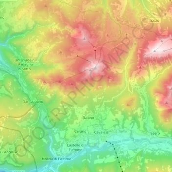
Name: Ville di Fiemme topographic map, elevation, terrain.
Average elevation: 1,440 m
Minimum elevation: 718 m
Maximum elevation: 2,478 m
Make a donation
Gear up for your next adventure:
As an Amazon Associate, this site earns from qualifying purchases at no extra cost to you.
Other topographic maps
Click on a map to view its topography, its elevation and its terrain.
Fiume Brenta
Italy > Trentino-Alto Adige/Südtirol > Provincia di Trento > Caldonazzo > Brenta
Average elevation: 470 m
Patascoss
Italy > Trentino-Alto Adige/Südtirol > Provincia di Trento > Madonna di Campiglio
Average elevation: 1,820 m
Castello San Giovanni
Italy > Trentino-Alto Adige/Südtirol > Provincia di Trento > Baitoni
Average elevation: 568 m
Make a donation
Gear up for your next adventure:
As an Amazon Associate, this site earns from qualifying purchases at no extra cost to you.
Poppekanzel - Pulpito di Cima Pope
Italy > Trentino-Alto Adige/Südtirol > Provincia di Trento
Average elevation: 2,035 m
Soraga
Italy > Trentino-Alto Adige/Südtirol > Provincia di Trento > Soraga di Fassa
Average elevation: 1,508 m
Make a donation
Gear up for your next adventure:
As an Amazon Associate, this site earns from qualifying purchases at no extra cost to you.
Alba - Dèlba
Italy > Trentino-Alto Adige/Südtirol > Provincia di Trento > Canazei
Average elevation: 1,842 m
Vadaione
Italy > Trentino-Alto Adige/Südtirol > Provincia di Trento > Giustino
Average elevation: 1,078 m
Make a donation
Gear up for your next adventure:
As an Amazon Associate, this site earns from qualifying purchases at no extra cost to you.
Malga Grassi
Italy > Trentino-Alto Adige/Südtirol > Provincia di Trento > Riva del Garda
Average elevation: 1,186 m
Moline
Italy > Trentino-Alto Adige/Südtirol > Provincia di Trento > San Lorenzo in Banale
Average elevation: 952 m
Ciago
Italy > Trentino-Alto Adige/Südtirol > Provincia di Trento > Vallelaghi > Vezzano
Average elevation: 804 m
Make a donation
Gear up for your next adventure:
As an Amazon Associate, this site earns from qualifying purchases at no extra cost to you.
Gruppo del Catinaccio
Italy > Trentino-Alto Adige/Südtirol > Provincia di Trento
Average elevation: 1,863 m
Teggiole
Italy > Trentino-Alto Adige/Südtirol > Provincia di Trento > Teggiole
Average elevation: 333 m
Sant'Alessandro
Italy > Trentino-Alto Adige/Südtirol > Provincia di Trento > Riva del Garda
Average elevation: 106 m
Pregasina
Italy > Trentino-Alto Adige/Südtirol > Provincia di Trento > Pregasina
Average elevation: 454 m
Make a donation
Gear up for your next adventure:
As an Amazon Associate, this site earns from qualifying purchases at no extra cost to you.
Make a donation
Gear up for your next adventure:
As an Amazon Associate, this site earns from qualifying purchases at no extra cost to you.