Geolocate

Jatiarjo topographic map

Click on the map to display elevation.

About this map

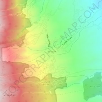
Name: Jatiarjo topographic map, elevation, terrain.

Location: Jatiarjo, Pasuruan, East Java, Java, Indonesia (-7.77024 112.64626 -7.73024 112.68626)

Average elevation: 725 m

Minimum elevation: 428 m

Maximum elevation: 1,084 m

Other topographic maps

Click on a map to view its topography, its elevation and its terrain.

Batas Desa Sumberanyar

Indonesia > East Java > Pasuruan

Average elevation: 39 m

Gear up for your next adventure:

🥾Trekking Boots - Durable boots for long-distance trekking
🧭GPS Outdoor Watch - Smart watch for navigation and fitness tracking in nature
🧰Multitool Knife - Compact and versatile tool for outdoor use
🧥Thermal Fleece Jacket - Versatile insulation for changing mountain temperatures
🎒Hiking Backpack - Lightweight and ergonomic backpacks for day hikes or multi-day treks

As an Amazon Associate, this site earns from qualifying purchases at no extra cost to you.