Geolocate

Biaan topographic map

Click on the map to display elevation.

About this map

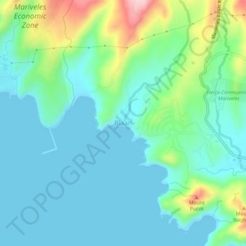
Name: Biaan topographic map, elevation, terrain.

Location: Biaan, Mariveles, Bataan, Central Luzon, 2105, Philippines (14.42201 120.43197 14.46201 120.47197)

Average elevation: 48 m

Minimum elevation: 0 m

Maximum elevation: 208 m

Other topographic maps

Click on a map to view its topography, its elevation and its terrain.

Lopez Jaena Park

Philippines > Bataan > Mariveles

Average elevation: 89 m

Laki Beach

Philippines > Bataan > Mariveles

Average elevation: 30 m

Laki Beach

Philippines > Bataan > Mariveles

Average elevation: 30 m

Gear up for your next adventure:

🎒Hiking Daypack - Lightweight and durable backpacks for day trips and excursions
🥾Light Hiking Boots - Lightweight and comfortable boots for day hikes
🧢Beanie Hat - Keep your head warm in cold weather
🚲Handlebar Phone Mount - View topographic-map.com live while cycling
Camping Tent - Weather-resistant tents suitable for 2 to 6 people

As an Amazon Associate, this site earns from qualifying purchases at no extra cost to you.