Geolocate

Warkworth topographic map

Click on the map to display elevation.

About this map
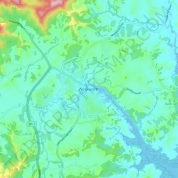
Name: Warkworth topographic map, elevation, terrain.

Location: Warkworth, Rodney, Auckland, 0910, New Zealand (-36.43767 174.62585 -36.35767 174.70585)

Average elevation: 60 m

Minimum elevation: 0 m

Maximum elevation: 329 m

Other topographic maps

Click on a map to view its topography, its elevation and its terrain.
Lake Rototoa

New Zealand > Auckland > Rodney

Average elevation: 102 m

Helensville

New Zealand > Auckland > Rodney

Average elevation: 21 m

Dome Forest

New Zealand > Auckland > Rodney

Average elevation: 168 m

Cowan Bay

New Zealand > Auckland > Rodney > Snells Beach

Average elevation: 22 m

Kawau Island

New Zealand > Auckland > Rodney

Average elevation: 26 m

Kawau Island

New Zealand > Auckland > Rodney

Average elevation: 26 m

Taupaki Estate

New Zealand > Auckland > Rodney > Kumeū

Average elevation: 37 m

Omaha Beach

New Zealand > Auckland > Rodney > Omaha

Average elevation: 3 m

Gear up for your next adventure:

☕Camping Coffee Maker - Brew fresh coffee anywhere on the topographic map
🧥Waterproof Pants - Keep dry during rainy hiking conditions
💧Hydration Bladder - Hands-free hydration solution for long treks
🧥Ultralight Puffy Jacket - Maximum warmth that packs down to the size of an orange
🔦LED Flashlight - Powerful and long-lasting flashlight for camping and emergencies

As an Amazon Associate, this site earns from qualifying purchases at no extra cost to you.