Geolocate

Gemolong topographic map

Click on the map to display elevation.

About this map

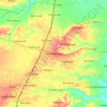
Name: Gemolong topographic map, elevation, terrain.

Location: Gemolong, Sragen, Central Java, Java, 57274, Indonesia (-7.43964 110.79551 -7.35964 110.87551)

Average elevation: 137 m

Minimum elevation: 93 m

Maximum elevation: 177 m

Gear up for your next adventure:

👟Leg Gaiters - Keep debris, mud, and snow out of your boots
🥾All-Terrain Hiking Boots - Versatile boots for varied hiking conditions
🧴Outdoor Sunscreen - High SPF protection for high-altitude UV exposure
🥾Mountain Hiking Shoes - Shoes with superior grip for mountainous terrain
💡Compact LED Flashlight - Powerful and portable flashlight for outdoor use

As an Amazon Associate, this site earns from qualifying purchases at no extra cost to you.