Geolocate

Juwangi topographic map

Click on the map to display elevation.

About this map

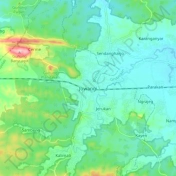
Name: Juwangi topographic map, elevation, terrain.

Location: Juwangi, Boyolali, Central Java, Java, 57391, Indonesia (-7.22609 110.71508 -7.14609 110.79508)

Average elevation: 83 m

Minimum elevation: 40 m

Maximum elevation: 228 m

Other topographic maps

Click on a map to view its topography, its elevation and its terrain.

Kecamatan Ngemplak

Indonesia > Central Java > Boyolali

Average elevation: 126 m

Selo

Indonesia > Central Java > Boyolali

Average elevation: 1,442 m

Lencoh

Indonesia > Central Java > Boyolali

Average elevation: 1,672 m

Klakah

Indonesia > Central Java > Boyolali

Average elevation: 1,237 m

Jrakah

Indonesia > Central Java > Boyolali

Average elevation: 1,569 m

Cepogo

Indonesia > Central Java > Boyolali

Average elevation: 1,308 m

Musuk

Indonesia > Central Java > Boyolali

Average elevation: 718 m

Gear up for your next adventure:

🥾Approach Shoes - Shoes designed for climbing approaches and rugged trails
🧥Fleece Jacket - Warm and lightweight jacket for layering
👖Convertible Hiking Pants - Zip-off legs to adapt to changing weather conditions
🔦LED Headtorch - Bright and durable light for night activities
🧥Thermal Layer - Insulating layer for cold outdoor conditions

As an Amazon Associate, this site earns from qualifying purchases at no extra cost to you.