Geolocate

Jambu topographic map

Click on the map to display elevation.

About this map

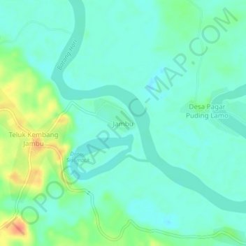
Name: Jambu topographic map, elevation, terrain.

Location: Jambu, Tebo, Jambi, Sumatra, Indonesia (-1.38687 102.31177 -1.34687 102.35177)

Average elevation: 45 m

Minimum elevation: 32 m

Maximum elevation: 81 m

Other topographic maps

Click on a map to view its topography, its elevation and its terrain.

Sungai Pandan

Indonesia > Jambi > Tebo > Tanjung Aur

Average elevation: 62 m

Sungai Rengas

Indonesia > Jambi > Tebo

Average elevation: 47 m

Sungai Hitam

Indonesia > Jambi > Tebo > Desa Wanareja

Average elevation: 74 m

Gear up for your next adventure:

Lightweight Backpacking Tent - Compact tent for efficient hiking trips
🔦LED Flashlight - Powerful and long-lasting flashlight for camping and emergencies
🪑Insulated Seat Pad - Protect your seat from cold rocks and wet logs
🔭Compact Binoculars - Lightweight optics for scouting trails and wildlife
🧥Thermal Layer - Insulating layer for cold outdoor conditions

As an Amazon Associate, this site earns from qualifying purchases at no extra cost to you.