
Thank you for supporting this site ❤️
Make a donation
Make a donation
Gear up for your next adventure:
As an Amazon Associate, this site earns from qualifying purchases at no extra cost to you.
Boleng topographic map
Click on the map to display elevation.
Thank you for supporting this site ❤️
Make a donation
Make a donation
Gear up for your next adventure:
As an Amazon Associate, this site earns from qualifying purchases at no extra cost to you.
About this map
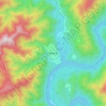
Name: Boleng topographic map, elevation, terrain.
Location: Boleng, Boleng ADC, Siang, Arunachal Pradesh, India (28.28244 94.91423 28.36244 94.99423)
Average elevation: 707 m
Minimum elevation: 186 m
Maximum elevation: 1,747 m
Thank you for supporting this site ❤️
Make a donation
Make a donation
Gear up for your next adventure:
As an Amazon Associate, this site earns from qualifying purchases at no extra cost to you.