Geolocate

Delta topographic map

Click on the map to display elevation.

About this map

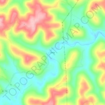
Name: Delta topographic map, elevation, terrain.

Location: Delta, Wayne County, Kentucky, United States (36.84452 -84.67716 36.88452 -84.63716)

Average elevation: 311 m

Minimum elevation: 235 m

Maximum elevation: 410 m

Other topographic maps

Click on a map to view its topography, its elevation and its terrain.

Monticello

United States > Kentucky > Wayne County

Average elevation: 304 m

Monticello

United States > Kentucky > Wayne County

Average elevation: 304 m

Gear up for your next adventure:

🔦LED Headlamp - Hands-free lighting for early morning starts or late finishes
🛶Kayak Dry Bag - Waterproof storage for kayaking adventures
🧰Emergency Multi-Tool - Compact multi-tool for outdoor survival
💡LED Camping Lantern - Illuminate your campsite with long-lasting lanterns
🧥Thermal Layer - Insulating layer for cold outdoor conditions

As an Amazon Associate, this site earns from qualifying purchases at no extra cost to you.