
Make a donation
Gear up for your next adventure:
As an Amazon Associate, this site earns from qualifying purchases at no extra cost to you.
Djebel Aïssa topographic map
Click on the map to display elevation.
Make a donation
Gear up for your next adventure:
As an Amazon Associate, this site earns from qualifying purchases at no extra cost to you.
Djebel Aïssa
Le djebel Aïssa (arabe : جبل عيسى) est une montagne culminant à 2 236 m d'altitude dans l'Ouest de l'Algérie, dans la wilaya de Naâma. C'est la 4e plus élevée en Algérie. Il est le point culminant des monts des Ksour dans l'Atlas saharien.
Make a donation
Gear up for your next adventure:
As an Amazon Associate, this site earns from qualifying purchases at no extra cost to you.
About this map
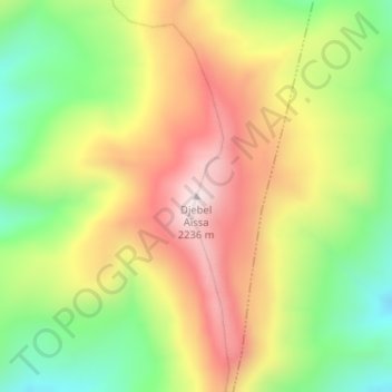
Name: Djebel Aïssa topographic map, elevation, terrain.
Location: Djebel Aïssa, Aïn Séfra, Daïra de Aïn Séfra, Naâma, Algérie (32.91178 -0.46761 32.91188 -0.46751)
Average elevation: 1,936 m
Minimum elevation: 1,654 m
Maximum elevation: 2,233 m
Make a donation
Gear up for your next adventure:
As an Amazon Associate, this site earns from qualifying purchases at no extra cost to you.