Geolocate

Manlleu topographic map

Click on the map to display elevation.

Manlleu

Manlleu is located in a large plain, La Plana de Vic, at around 460 metres above sea level on average. The highest point is Puig Agut church at around 594 m above the sea level. It is surrounded by mountains with altitudes over 1000 m.

Wikipedia (CC-BY-SA 3.0)

About this map

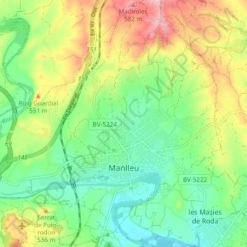
Name: Manlleu topographic map, elevation, terrain.

Location: Manlleu, Osona, Barcelona, Catalonia, 08560, Spain (41.98424 2.24323 42.03381 2.31094)

Average elevation: 491 m

Minimum elevation: 429 m

Maximum elevation: 591 m

Other topographic maps

Click on a map to view its topography, its elevation and its terrain.

Pla de la Calma

Spain > Catalonia > Osona > el Brull

Average elevation: 1,111 m

Taradell

Spain > Catalonia > Osona > Taradell > Taradell

Average elevation: 617 m

Sora

Spain > Catalonia > Osona > Sora > Sora

Average elevation: 750 m

Gear up for your next adventure:

💧Filtered Water Bottle - Safe drinking water on the go
💡Compact LED Flashlight - Powerful and portable flashlight for outdoor use
🥾Light Hiking Boots - Lightweight and comfortable boots for day hikes
🧴Bear Spray Holster - Quick-access carry for essential Canadian wilderness safety
🌬️Windproof Camp Stove - Efficient cooking even on exposed mountain peaks

As an Amazon Associate, this site earns from qualifying purchases at no extra cost to you.