Geolocate

Narghota topographic map

Click on the map to display elevation.

About this map

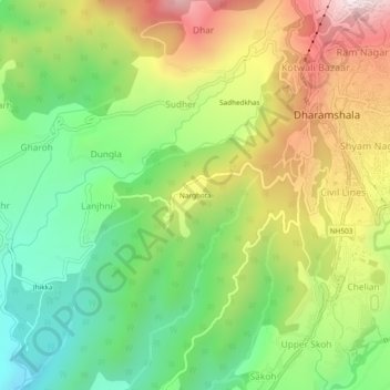
Name: Narghota topographic map, elevation, terrain.

Location: Narghota, Dharamshala, Kangra, Himachal Pradesh, 176200, India (32.18607 76.28372 32.22607 76.32372)

Average elevation: 1,108 m

Minimum elevation: 783 m

Maximum elevation: 1,554 m

Other topographic maps

Click on a map to view its topography, its elevation and its terrain.

Balh

India > Himachal Pradesh > Dharamshala > Dharamshala

Average elevation: 1,906 m

Gear up for your next adventure:

🧢Outdoor Cap - Protective cap for sun and rain during hikes
🎒Fully Waterproof Backpack - Total protection for photography gear and electronics
🛶Waterproof Dry Bags - Keep electronics and clothes dry during river crossings
🕯️Camping Lantern - Illuminates your entire campsite with high-efficiency LEDs
🦌Outdoor Trail Camera - Monitor wildlife activity near your favorite spots

As an Amazon Associate, this site earns from qualifying purchases at no extra cost to you.