
Thank you for supporting this site ❤️
Make a donation
Make a donation
Gear up for your next adventure:
As an Amazon Associate, this site earns from qualifying purchases at no extra cost to you.
Papallacta topographic map
Click on the map to display elevation.
Thank you for supporting this site ❤️
Make a donation
Make a donation
Gear up for your next adventure:
As an Amazon Associate, this site earns from qualifying purchases at no extra cost to you.
Papallacta
Papallacta is a village at an altitude of 3,300 metres (10,827 feet) in Napo Province, Ecuador. Its population is 635 as of 2022.
Thank you for supporting this site ❤️
Make a donation
Make a donation
Gear up for your next adventure:
As an Amazon Associate, this site earns from qualifying purchases at no extra cost to you.
About this map
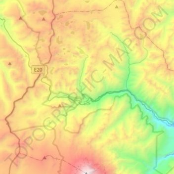
Name: Papallacta topographic map, elevation, terrain.
Location: Papallacta, Quijos, Napo, Ecuador (-0.48438 -78.25596 -0.24104 -78.07250)
Average elevation: 3,809 m
Minimum elevation: 2,352 m
Maximum elevation: 5,692 m
Thank you for supporting this site ❤️
Make a donation
Make a donation
Gear up for your next adventure:
As an Amazon Associate, this site earns from qualifying purchases at no extra cost to you.