
Make a donation
Gear up for your next adventure:
As an Amazon Associate, this site earns from qualifying purchases at no extra cost to you.
Achern topographic map
Click on the map to display elevation.
Make a donation
Gear up for your next adventure:
As an Amazon Associate, this site earns from qualifying purchases at no extra cost to you.
About this map
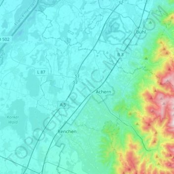
Name: Achern topographic map, elevation, terrain.
Average elevation: 266 m
Minimum elevation: 112 m
Maximum elevation: 1,162 m
Make a donation
Gear up for your next adventure:
As an Amazon Associate, this site earns from qualifying purchases at no extra cost to you.
Other topographic maps
Click on a map to view its topography, its elevation and its terrain.
Reichenbach
Deutschland > Baden-Württemberg > Ortenaukreis > Lahr/Schwarzwald
Average elevation: 295 m
Kirnbach
Deutschland > Baden-Württemberg > Ortenaukreis > Zell am Harmersbach > Unterharmersbach
Average elevation: 393 m
Make a donation
Gear up for your next adventure:
As an Amazon Associate, this site earns from qualifying purchases at no extra cost to you.
Alte Straße
Deutschland > Baden-Württemberg > Ortenaukreis > Gutach (Schwarzwaldbahn) > Gutach > Alte Straße
Average elevation: 478 m
Bottenau
Deutschland > Baden-Württemberg > Ortenaukreis > Oberkirch > Bottenau
Average elevation: 251 m
Make a donation
Gear up for your next adventure:
As an Amazon Associate, this site earns from qualifying purchases at no extra cost to you.
Mummelsee
Deutschland > Baden-Württemberg > Ortenaukreis > Seebach
Der Mummelsee ist ein Karsee auf 1028,5 m ü. NN[1] Höhe am Abhang der Hornisgrinde im Schwarzwald. Er ist 3,7 Hektar groß und 18 Meter tief.[2] Er zählt zu den meistbesuchten Seen in Baden-Württemberg, da er direkt an der Schwarzwaldhochstraße liegt. Die touristischen Einrichtungen am See bilden den…
Average elevation: 922 m