Geolocate

Kenyam topographic map

Click on the map to display elevation.

About this map

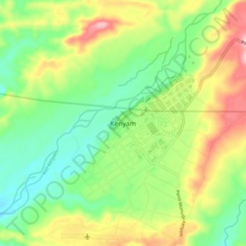
Name: Kenyam topographic map, elevation, terrain.

Location: Kenyam, Nduga, Highland Papua, Western New Guinea, Indonesia (-4.64148 138.34363 -4.56148 138.42363)

Average elevation: 147 m

Minimum elevation: 61 m

Maximum elevation: 282 m

Other topographic maps

Click on a map to view its topography, its elevation and its terrain.

Iniye River

Indonesia > Highland Papua > Nduga > Kosabak

Average elevation: 2,184 m

Wusak River

Indonesia > Highland Papua > Nduga

Average elevation: 1,130 m

Gear up for your next adventure:

🛏️Camping Sleeping Mat - Comfortable mats for sleeping outdoors
🧭GPS Outdoor Watch - Smart watch for navigation and fitness tracking in nature
🪑Insulated Seat Pad - Protect your seat from cold rocks and wet logs
🔦UV Flashlight - Detect minerals or specific insects in the dark
🛌Down Sleeping Bag - Superior warmth-to-weight ratio for cold nights

As an Amazon Associate, this site earns from qualifying purchases at no extra cost to you.