Geolocate

Leuwikoja topographic map

Click on the map to display elevation.

About this map

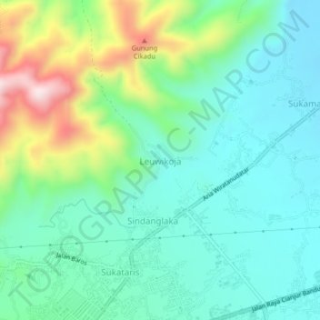
Name: Leuwikoja topographic map, elevation, terrain.

Location: Leuwikoja, Cianjur, West Java, Java, 43281, Indonesia (-6.80278 107.14506 -6.76278 107.18506)

Average elevation: 420 m

Minimum elevation: 295 m

Maximum elevation: 756 m

Other topographic maps

Click on a map to view its topography, its elevation and its terrain.

Kertajadi

Indonesia > West Java > Cianjur

Average elevation: 108 m

Agrabinta

Indonesia > West Java > Cianjur

Average elevation: 108 m

Cidaun

Indonesia > West Java > Cianjur

Average elevation: 658 m

Karangwangi

Indonesia > West Java > Cianjur

Average elevation: 119 m

Wanasari

Indonesia > West Java > Cianjur

Average elevation: 31 m

Jayapura

Indonesia > West Java > Cianjur

Average elevation: 73 m

Cisalak

Indonesia > West Java > Cianjur

Average elevation: 49 m

Gear up for your next adventure:

🧦Thermal Socks - Warm socks for winter hiking or camping
🧥Waterproof Hiking Jacket - Protect yourself from rain and wind while hiking
🥾Trail Hiking Boots - Supportive boots for rough trails
🔥Camping Stove - Portable stoves to cook outdoors with ease
Lightweight Backpacking Tent - Compact tent for efficient hiking trips

As an Amazon Associate, this site earns from qualifying purchases at no extra cost to you.