
Make a donation
Gear up for your next adventure:
As an Amazon Associate, this site earns from qualifying purchases at no extra cost to you.
Zeitz topographic map
Click on the map to display elevation.
Make a donation
Gear up for your next adventure:
As an Amazon Associate, this site earns from qualifying purchases at no extra cost to you.
About this map
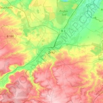
Name: Zeitz topographic map, elevation, terrain.
Location: Zeitz, Burgenlandkreis, Saxony-Anhalt, Germany (50.97121 12.04578 51.13014 12.27785)
Average elevation: 210 m
Minimum elevation: 118 m
Maximum elevation: 303 m
Make a donation
Gear up for your next adventure:
As an Amazon Associate, this site earns from qualifying purchases at no extra cost to you.
Other topographic maps
Click on a map to view its topography, its elevation and its terrain.
Tromsdorf
Germany > Saxony-Anhalt > Burgenlandkreis > Eckartsberga > Tromsdorf
Average elevation: 195 m
Plößnitz
Germany > Saxony-Anhalt > Burgenlandkreis > Laucha an der Unstrut > Plößnitz
Average elevation: 206 m