
Make a donation
Gear up for your next adventure:
As an Amazon Associate, this site earns from qualifying purchases at no extra cost to you.
Helmer topographic map
Click on the map to display elevation.
Make a donation
Gear up for your next adventure:
As an Amazon Associate, this site earns from qualifying purchases at no extra cost to you.
About this map
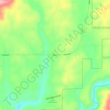
Name: Helmer topographic map, elevation, terrain.
Location: Helmer, Latah County, Idaho, United States (46.78073 -116.49015 46.82073 -116.45015)
Average elevation: 870 m
Minimum elevation: 794 m
Maximum elevation: 986 m
Make a donation
Gear up for your next adventure:
As an Amazon Associate, this site earns from qualifying purchases at no extra cost to you.
Other topographic maps
Click on a map to view its topography, its elevation and its terrain.
Onaway
United States > Idaho > Latah County
Onaway is located at 46°55′43″N 116°53′21″W / 46.92861°N 116.88917°W / 46.92861; -116.88917 (46.928565, -116.889074), at an elevation of 2,621 feet (799 m) above sea level. According to the United States Census Bureau, the city has a total area of 0.15 square miles (0.39 km2), all of it land.
Average elevation: 794 m
Genesee
United States > Idaho > Latah County
Genesee is located at 46°33.0′N 116°55.5′W / 46.5500°N 116.9250°W / 46.5500; -116.9250 (46.5506, -116.9245)., at an elevation of 2,680 feet (817 m) above sea level. Located in the Palouse region, it is approximately 14 miles (23 km) south of Moscow, about halfway to Lewiston. The city center…
Average elevation: 824 m
Bovill
United States > Idaho > Latah County
Bovill is located at 46°51′33″N 116°23′40″W / 46.85917°N 116.39444°W / 46.85917; -116.39444 (46.859187, -116.394491), at an elevation of 2,874 feet (876 m) above sea level on the east bank of the Potlatch River.
Average elevation: 907 m
Make a donation
Gear up for your next adventure:
As an Amazon Associate, this site earns from qualifying purchases at no extra cost to you.