Geolocate

Cihaurbeuti topographic map

Click on the map to display elevation.

About this map

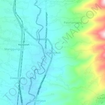
Name: Cihaurbeuti topographic map, elevation, terrain.

Location: Cihaurbeuti, Ciamis, West Java, Java, 46262, Indonesia (-7.23876 108.19524 -7.19876 108.23524)

Average elevation: 639 m

Minimum elevation: 425 m

Maximum elevation: 1,146 m

Other topographic maps

Click on a map to view its topography, its elevation and its terrain.

Mangkubumi

Indonesia > West Java > Ciamis

Average elevation: 351 m

Sadananya

Indonesia > West Java > Ciamis

Average elevation: 538 m

Sindangkasih

Indonesia > West Java > Ciamis

Average elevation: 442 m

Kertasari

Indonesia > West Java > Ciamis > Ciamis

Average elevation: 181 m

Cijeungjing

Indonesia > West Java > Ciamis

Average elevation: 167 m

Lakbok

Indonesia > West Java > Ciamis

Average elevation: 22 m

Panyingkiran

Indonesia > West Java > Ciamis > Ciamis

Average elevation: 246 m

Gear up for your next adventure:

🧥Softshell Jacket - Windproof and breathable jacket for hiking
🐕Hiking Dog Pack - Let your canine companion carry their own water and food
💡Compact LED Flashlight - Powerful and portable flashlight for outdoor use
🥾Hiking Gaiters - Protect legs and shoes from mud, snow, and debris
🧦Hiking Liner Socks - Thin base layer to prevent friction and blisters

As an Amazon Associate, this site earns from qualifying purchases at no extra cost to you.