Geolocate

Selajambe topographic map

Click on the map to display elevation.

About this map

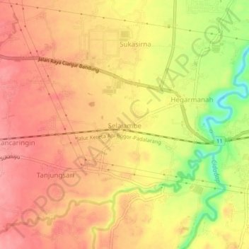
Name: Selajambe topographic map, elevation, terrain.

Location: Selajambe, Cianjur, West Java, Java, 43282, Indonesia (-6.83271 107.20718 -6.79271 107.24718)

Average elevation: 276 m

Minimum elevation: 214 m

Maximum elevation: 306 m

Other topographic maps

Click on a map to view its topography, its elevation and its terrain.

Cidaun

Indonesia > West Java > Cianjur

Average elevation: 658 m

Kertajadi

Indonesia > West Java > Cianjur

Average elevation: 108 m

Agrabinta

Indonesia > West Java > Cianjur

Average elevation: 108 m

Karangwangi

Indonesia > West Java > Cianjur

Average elevation: 119 m

Wanasari

Indonesia > West Java > Cianjur

Average elevation: 31 m

Cisalak

Indonesia > West Java > Cianjur

Average elevation: 49 m

Jayapura

Indonesia > West Java > Cianjur

Average elevation: 73 m

Gear up for your next adventure:

🍽️Titanium Camping Spork - Ultralight and indestructible eating utensil
🧭GPS Tracker - Track your location in remote areas safely
🕯️Camping Lantern - Illuminates your entire campsite with high-efficiency LEDs
Backpacking Tent - Lightweight tent for long-distance hiking trips
🥾Mountain Hiking Shoes - Shoes with superior grip for mountainous terrain

As an Amazon Associate, this site earns from qualifying purchases at no extra cost to you.