Geolocate

Armiñón topographic map

Click on the map to display elevation.

About this map

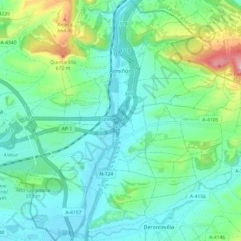
Name: Armiñón topographic map, elevation, terrain.

Location: Armiñón, Añanako kuadrilla/Cuadrilla de Añana, Álava, Autonomous Community of the Basque Country, 01220, Spain (42.67935 -2.90515 42.74053 -2.83890)

Average elevation: 520 m

Minimum elevation: 453 m

Maximum elevation: 746 m

Other topographic maps

Click on a map to view its topography, its elevation and its terrain.

Gear up for your next adventure:

🥾Waterproof Trail Shoes - Shoes designed to handle wet terrain
🧭GPS Outdoor Watch - Smart watch for navigation and fitness tracking in nature
🚲Bike Repair Kit - Essential tools for on-trail mechanical issues
🛌Insulated Sleeping Pad - Critical thermal barrier between you and the cold ground
🛰️Satellite Messenger - Emergency communication for areas with no cell service

As an Amazon Associate, this site earns from qualifying purchases at no extra cost to you.