Geolocate

Balepanjang topographic map

Click on the map to display elevation.

About this map

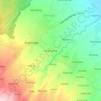
Name: Balepanjang topographic map, elevation, terrain.

Location: Balepanjang, Jogorogo, Ngawi, East Java, Java, Indonesia (-7.54531 111.23956 -7.50531 111.27956)

Average elevation: 320 m

Minimum elevation: 200 m

Maximum elevation: 486 m

Gear up for your next adventure:

❄️Traction Ice Cleats - Slip-on spikes for icy trails and winter hiking
Lightweight Backpacking Tent - Compact tent for efficient hiking trips
💡Solar Camping Lamp - Eco-friendly lighting for campsites
🏃Hydration Running Vest - Carry water and maps close to your body for speed
🧢Sun Hat - Wide-brim hat for sun protection

As an Amazon Associate, this site earns from qualifying purchases at no extra cost to you.