Geolocate

Campaka topographic map

Click on the map to display elevation.

About this map

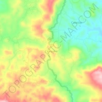
Name: Campaka topographic map, elevation, terrain.

Location: Campaka, Cianjur, West Java, Java, Indonesia (-7.05190 107.10379 -6.97190 107.18379)

Average elevation: 940 m

Minimum elevation: 498 m

Maximum elevation: 1,319 m

Other topographic maps

Click on a map to view its topography, its elevation and its terrain.

Cidaun

Indonesia > West Java > Cianjur

Average elevation: 658 m

Kertajadi

Indonesia > West Java > Cianjur

Average elevation: 108 m

Agrabinta

Indonesia > West Java > Cianjur

Average elevation: 108 m

Karangwangi

Indonesia > West Java > Cianjur

Average elevation: 119 m

Wanasari

Indonesia > West Java > Cianjur

Average elevation: 31 m

Cisalak

Indonesia > West Java > Cianjur

Average elevation: 49 m

Jayapura

Indonesia > West Java > Cianjur

Average elevation: 73 m

Gear up for your next adventure:

🧥Insulated Jacket - Keep warm in cold outdoor conditions
🕶️Polarized Sunglasses - Protect your eyes with durable polarized lenses
👖Convertible Hiking Pants - Zip-off legs to adapt to changing weather conditions
Lightweight Camping Tent - Portable shelter optimized for Canadian backcountry camping
Camping Groundsheet - Protect your tent from moisture and dirt

As an Amazon Associate, this site earns from qualifying purchases at no extra cost to you.