
Make a donation
Gear up for your next adventure:
As an Amazon Associate, this site earns from qualifying purchases at no extra cost to you.
Le Pont-de-Montvert topographic map
Click on the map to display elevation.
Make a donation
Gear up for your next adventure:
As an Amazon Associate, this site earns from qualifying purchases at no extra cost to you.
About this map
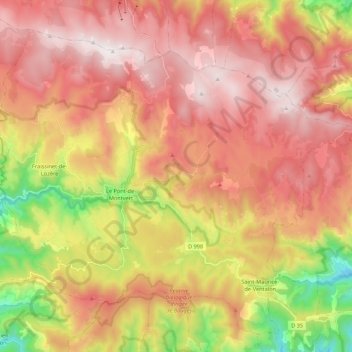
Name: Le Pont-de-Montvert topographic map, elevation, terrain.
Average elevation: 1,224 m
Minimum elevation: 578 m
Maximum elevation: 1,701 m
Make a donation
Gear up for your next adventure:
As an Amazon Associate, this site earns from qualifying purchases at no extra cost to you.
Other topographic maps
Click on a map to view its topography, its elevation and its terrain.
La Brousse
France > Occitanie > Lozère > Pont de Montvert - Sud Mont Lozère
Average elevation: 1,290 m
Pic Cassini
France > Occitanie > Lozère > Pont de Montvert - Sud Mont Lozère
Average elevation: 1,539 m
Sommet de Finiels
France > Occitanie > Lozère > Pont de Montvert - Sud Mont Lozère
La position et l'altitude de ce point permettent par temps très clair de voir la chaîne des Alpes à l'est, la mer Méditerranée au sud et le Plomb du Cantal au nord-ouest.
Average elevation: 1,571 m
Make a donation
Gear up for your next adventure:
As an Amazon Associate, this site earns from qualifying purchases at no extra cost to you.
Mas de la Barque
France > Occitanie > Lozère > Pont de Montvert - Sud Mont Lozère
Average elevation: 1,410 m
Make a donation
Gear up for your next adventure:
As an Amazon Associate, this site earns from qualifying purchases at no extra cost to you.
Tourbiere du lac
France > Occitanie > Lozère > Pont de Montvert - Sud Mont Lozère
Average elevation: 1,100 m
Runes
France > Occitanie > Lozère > Pont de Montvert - Sud Mont Lozère > Fraissinet-de-Lozère
Average elevation: 1,042 m
Bellecoste
France > Occitanie > Lozère > Pont de Montvert - Sud Mont Lozère > Bellecoste
Average elevation: 1,423 m
Make a donation
Gear up for your next adventure:
As an Amazon Associate, this site earns from qualifying purchases at no extra cost to you.