Geolocate

Bernad topographic map

Click on the map to display elevation.

About this map

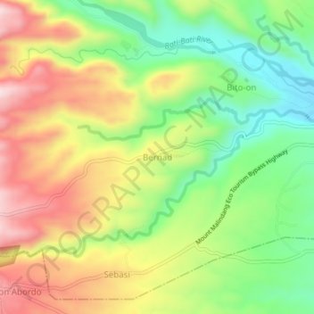
Name: Bernad topographic map, elevation, terrain.

Location: Bernad, Misamis Occidental, Northern Mindanao, Philippines (8.19383 123.72452 8.23383 123.76452)

Average elevation: 350 m

Minimum elevation: 157 m

Maximum elevation: 577 m

Other topographic maps

Click on a map to view its topography, its elevation and its terrain.

Bonifacio

Philippines > Misamis Occidental

Average elevation: 297 m

Ozamiz

Philippines > Misamis Occidental

Average elevation: 113 m

Tangub

Philippines > Misamis Occidental

Average elevation: 148 m

Ozamiz

Philippines > Misamis Occidental

Average elevation: 113 m

Ozamiz

Philippines > Misamis Occidental

Average elevation: 113 m

Ozamiz

Philippines > Misamis Occidental

Average elevation: 113 m

Tangub

Philippines > Misamis Occidental

Average elevation: 148 m

Ozamiz

Philippines > Misamis Occidental

Average elevation: 113 m

Gear up for your next adventure:

🥾Trail Hiking Boots - Supportive boots for rough trails
🧥Waterproof Hiking Jacket - Protect yourself from rain and wind while hiking
🔋Lithium AA Batteries - Long-lasting power that performs in extreme cold
🥽Outdoor Goggles - Protective eyewear for outdoor activities
🧳Compression Sacks - Maximize space in your backpack by shrinking gear

As an Amazon Associate, this site earns from qualifying purchases at no extra cost to you.