Geolocate

Alexisbad topographic map

Click on the map to display elevation.

About this map

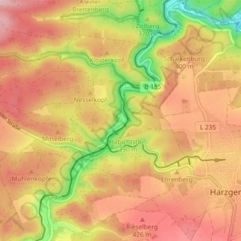
Name: Alexisbad topographic map, elevation, terrain.

Location: Alexisbad, Harzgerode, Landkreis Harz, Saxony-Anhalt, Germany (51.62994 11.09653 51.66994 11.13653)

Average elevation: 383 m

Minimum elevation: 270 m

Maximum elevation: 458 m

Gear up for your next adventure:

Camping Coffee Maker - Brew fresh coffee anywhere on the topographic map
🧦Thermal Socks - Warm socks for winter hiking or camping
🧭GPS Tracker - Track your location in remote areas safely
🚲Handlebar Phone Mount - View topographic-map.com live while cycling
🧢Sun Hat - Wide-brim hat for sun protection

As an Amazon Associate, this site earns from qualifying purchases at no extra cost to you.