Geolocate

Pine Cliffs topographic map

Click on the map to display elevation.

About this map

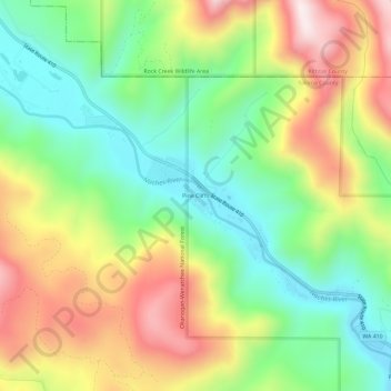
Name: Pine Cliffs topographic map, elevation, terrain.

Location: Pine Cliffs, Yakima County, Washington, United States (46.87913 -121.03240 46.91913 -120.99240)

Average elevation: 909 m

Minimum elevation: 655 m

Maximum elevation: 1,269 m

Other topographic maps

Click on a map to view its topography, its elevation and its terrain.

Yakima

United States > Washington > Yakima County

Average elevation: 377 m

Selah

United States > Washington > Yakima County

Average elevation: 395 m

Sunnyside

United States > Washington > Yakima County

Average elevation: 226 m

Naches

United States > Washington > Yakima County

Average elevation: 478 m

Wenas Lake

United States > Washington > Yakima County

Average elevation: 631 m

Nile

United States > Washington > Yakima County > Nile

Average elevation: 806 m

Toppenish

United States > Washington > Yakima County

Average elevation: 232 m

Yakima

United States > Washington > Yakima County

Average elevation: 377 m

Grandview

United States > Washington > Yakima County

Average elevation: 237 m

Sunnyside

United States > Washington > Yakima County

Average elevation: 226 m

Sunnyside

United States > Washington > Yakima County

Average elevation: 226 m

Yakima

United States > Washington > Yakima County

Average elevation: 377 m

Nile

United States > Washington > Yakima County > Nile

Average elevation: 806 m

Gleed

United States > Washington > Yakima County

Average elevation: 424 m

Nile

United States > Washington > Yakima County > Nile

Average elevation: 806 m

Yakima

United States > Washington > Yakima County

Average elevation: 377 m

Yakima

United States > Washington > Yakima County

Average elevation: 377 m

Tampico

United States > Washington > Yakima County > Tampico

Average elevation: 705 m

Wapato

United States > Washington > Yakima County

Average elevation: 260 m

Union Gap

United States > Washington > Yakima County

Average elevation: 316 m

Nile

United States > Washington > Yakima County > Nile

Average elevation: 806 m

Selah

United States > Washington > Yakima County

Average elevation: 395 m

Tieton

United States > Washington > Yakima County

Average elevation: 594 m

Nile

United States > Washington > Yakima County > Nile

Average elevation: 806 m

Mabton

United States > Washington > Yakima County

Average elevation: 218 m

Nile

United States > Washington > Yakima County > Nile

Average elevation: 806 m

Zillah

United States > Washington > Yakima County

Average elevation: 260 m

Gear up for your next adventure:

🚲Handlebar Phone Mount - View topographic-map.com live while cycling
🧢Hiking Sun Hat - Wide-brimmed protection for exposed mountain ridges
💧Hydration Pack - Hands-free hydration system for long hikes
🛶Waterproof Dry Bags - Keep electronics and clothes dry during river crossings
🪜Heavy Duty Carabiners - Multi-use clips for securing gear to your backpack

As an Amazon Associate, this site earns from qualifying purchases at no extra cost to you.