Geolocate

Chinchinim topographic map

Click on the map to display elevation.

About this map

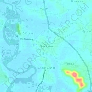
Name: Chinchinim topographic map, elevation, terrain.

Location: Chinchinim, Salcete, South Goa, Goa, 403715, India (15.19138 73.95720 15.23138 73.99720)

Average elevation: 8 m

Minimum elevation: -2 m

Maximum elevation: 85 m

Other topographic maps

Click on a map to view its topography, its elevation and its terrain.

Sal

India > Goa > Salcete > Parlmar Grande

Average elevation: 15 m

Gear up for your next adventure:

🦟Insect Repellent - Keep mosquitoes and black flies away in wooded areas
🎒Hiking Backpack - Lightweight and ergonomic backpacks for day hikes or multi-day treks
💧Collapsible Water Bottle - Space-saving water bottle for outdoor activities
🧰Multitool Knife - Compact and versatile tool for outdoor use
🧊Insulated Water Bottle - Keeps drinks cold in summer and prevents freezing in winter

As an Amazon Associate, this site earns from qualifying purchases at no extra cost to you.